Settlement Research
Earliest Population and Settlement in North Korea
History:
According to the research, People have been living on the Korean peninsula since prehistoric times, slowly developing their own distinct culture and civilization. The Korean people were first united by the Silla Dynasty in 668 A.D(History).
Climate and Geography:
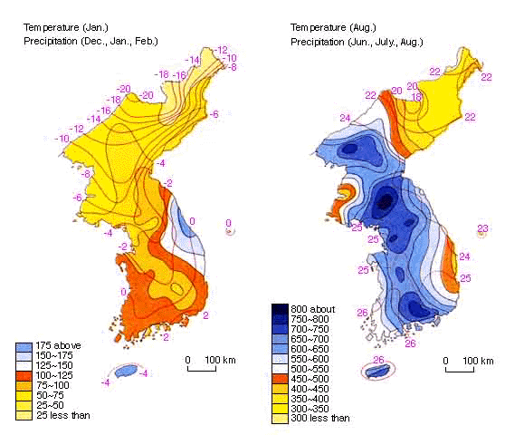
North Korea has a generally cool continental climate. The winter season is from December to March, it is long and cold. The average temperature in south is 20F and in northern interior is -10F. The summer is from June to September, it is warm and the temperature usually above the upper 60s F.
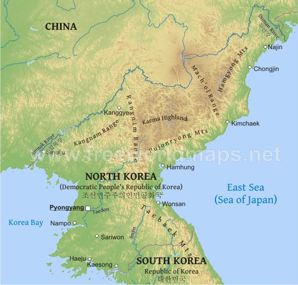
North Korea is bordered by the China and Russia on the north, on the east by the Sea of Japan, on the west by the Yellow Sea, and on the south by South Korea. Hills and mountains cover almost the entire country, with narrow valleys and small plains in between (Lee & Yu). The major mountain ranges are located in the north-central and northeastern sections of North Korea and along the eastern coast. On the eastern coast, the hills drop sharply down to a narrow coastal plain, whereas on the west coast the slope is more gradual, forming broad, level plains (North). North Korea has no active volcanoes and does not experience severe earthquakes.
Populations:
North Korea's population is concentrated in the plains and lowlands. The least populated regions are the mountainous Chagang and Yanggang provinces adjacent to the Chinese border; the largest concentrations of population are in North P'yngan and South P'yngan provinces, in the municipal district of P'yongyang, and in South Hamgyng Province, which includes the Hamhng-Hngnam urban area (History). The average population density at 167 persons per square kilometer, ranging from 1,178 persons per square kilometer in P'yongyang Municipality to 44 persons per square kilometer in Yanggang Province. By contrast, South Korea had an average population density of 425 persons per square kilometer in 1989 (Settlement).
Agriculture
Less than one-fourth of the area is cultivated. Along with the decrease in farm population, the proportion of national income derived from agriculture has decreased to a fraction of what it was in the early 1950s (Lee & Yu). Improvements in agricultural productivity have been hampered for a long time, since the fields are usually divided into small plots cultivated mainly by manual and animal forces.
Resources
Mineral resources in South Korea are meagre. The most important reserves are of anthracite coal, iron ore, graphite, gold, silver, tungsten, lead, and zinc, which together constitute some two-thirds of the total value of mineral resources. Deposits of graphite and tungsten are among the largest in the world.
Settlement patterns
If you close examination reveals numerous distinct settlement regions, you will find each one has different natural environment and historical background. North Korea now has nine provide, but according to the researches, during the Chosõn dynasty (1392-1910) the unified country had eight. Of those, North korea contains different natural settlement regions, each with a different environment and historical background. North Korea contains three provinces: P’yŏngan, Hwanghae, and Hamgyŏng and the northern parts of Kangwŏn and Kyŏnggi provinces (South). Each province not only was a political unit but also had characteristics of a cultural region in terms of dialect, customs, and way of life (Lee & Yu). North Korea may also be divided into the two larger traditional regions: Kwansŏ to the west and Kwanbuk to the east, roughly divided by the Nangnim Mountains. Kwansŏ comprises the current provinces of North P’yŏngan, South P’yŏngan, North Hwanghae, South Hwanghae, and Chagang, while Kwanbuk includes North Hamgyŏng, South Hamgyŏng, Yanggang, and Kangwŏn provinces (Lee & Yu).
Most of the rural population inhabits the eastern and western coastal lowlands and river valley plains. Because of the climates, the inland areas of Chagang and Yanggang provinces are sparsely settled because the lack of arable land and the cold climate, which does not permit the cultivation of rice. Lowland and valley plain villages usually gather at the base of the southern slope of the hillside, which provides protection from the cols northwest winter monsoon. The scattered land is cultivated by the Kaema Heights, especially by a small number of moving cultivators in Yanggang Province. The Upper Yaw and Tumen valleys contain settlements associated with woodcutters, and there are lots of fishing villages along the coast, especially on the eastern side of the peninsula.
Summary
For me, I don not think that Europeans were in any way culturally or racially superior to people of other parts of the world, but European European economic, military, technological, and political power came about not just because of geographical luck,
For the Jared theory, I want to talk about that Jared states that different civilizations arose differently, at various speeds because of their physical geography, not racial or biological differences. According to research, hills and mountains cover almost the entire country and the geography effect the agriculture in both South and North Korea. Today South Korea is one of the four economic "young tigers." North Koreans are starving. The same people, the same land, yet much different results. Politics can make a greater difference in the development of a country's life then environmental factors. The difference in prosperity between North and South Korea is due to different policies of North and South Korea’s governments today.
North and South Korea had previously shared history, language and culture which split in the 20th century due to war and differences in political and economic ideologies. This situation involves one new country vastly outperforming it’s counterpart in a short time by measures of standard of living, political liberties, civil freedoms and most other originations. The only independent variable is South Korea favored democracy, free markets and the rule of law. So, there are more factors at play in how different civilizations develop. For example, societal institutions, values, economic systems, culture, and political ideology influence a nation's trajectory far more than 'bio-geographical' factors as Jared asserts.
Works Citied
History of North Korea. (n.d.). Retrieved January 23, 2017, from
http://www.libertyinnorthkorea.org/learn-north-korea-history/
Lee, C., & Yu, W. (2016, December 07). North Korea. Retrieved
January 23, 2017, from https://www.britannica.com/place/North-Korea/People
Settlement Patterns and Urbanization of North Korea. (n.d.).
Retrieved January 23, 2017, from http://www.country-data.com/cgi-bin/query/r-9522.html
North Korea. (n.d.). Retrieved January 24, 2017, from
http://www.encyclopedia.com/places/asia/korean-political-
History:
According to the research, People have been living on the Korean peninsula since prehistoric times, slowly developing their own distinct culture and civilization. The Korean people were first united by the Silla Dynasty in 668 A.D(History).
Climate and Geography:
North Korea has a generally cool continental climate. The winter season is from December to March, it is long and cold. The average temperature in south is 20F and in northern interior is -10F. The summer is from June to September, it is warm and the temperature usually above the upper 60s F.
North Korea is bordered by the China and Russia on the north, on the east by the Sea of Japan, on the west by the Yellow Sea, and on the south by South Korea. Hills and mountains cover almost the entire country, with narrow valleys and small plains in between (Lee & Yu). The major mountain ranges are located in the north-central and northeastern sections of North Korea and along the eastern coast. On the eastern coast, the hills drop sharply down to a narrow coastal plain, whereas on the west coast the slope is more gradual, forming broad, level plains (North). North Korea has no active volcanoes and does not experience severe earthquakes.
Populations:
North Korea's population is concentrated in the plains and lowlands. The least populated regions are the mountainous Chagang and Yanggang provinces adjacent to the Chinese border; the largest concentrations of population are in North P'yngan and South P'yngan provinces, in the municipal district of P'yongyang, and in South Hamgyng Province, which includes the Hamhng-Hngnam urban area (History). The average population density at 167 persons per square kilometer, ranging from 1,178 persons per square kilometer in P'yongyang Municipality to 44 persons per square kilometer in Yanggang Province. By contrast, South Korea had an average population density of 425 persons per square kilometer in 1989 (Settlement).
Agriculture
Less than one-fourth of the area is cultivated. Along with the decrease in farm population, the proportion of national income derived from agriculture has decreased to a fraction of what it was in the early 1950s (Lee & Yu). Improvements in agricultural productivity have been hampered for a long time, since the fields are usually divided into small plots cultivated mainly by manual and animal forces.
Resources
Mineral resources in South Korea are meagre. The most important reserves are of anthracite coal, iron ore, graphite, gold, silver, tungsten, lead, and zinc, which together constitute some two-thirds of the total value of mineral resources. Deposits of graphite and tungsten are among the largest in the world.
Settlement patterns
If you close examination reveals numerous distinct settlement regions, you will find each one has different natural environment and historical background. North Korea now has nine provide, but according to the researches, during the Chosõn dynasty (1392-1910) the unified country had eight. Of those, North korea contains different natural settlement regions, each with a different environment and historical background. North Korea contains three provinces: P’yŏngan, Hwanghae, and Hamgyŏng and the northern parts of Kangwŏn and Kyŏnggi provinces (South). Each province not only was a political unit but also had characteristics of a cultural region in terms of dialect, customs, and way of life (Lee & Yu). North Korea may also be divided into the two larger traditional regions: Kwansŏ to the west and Kwanbuk to the east, roughly divided by the Nangnim Mountains. Kwansŏ comprises the current provinces of North P’yŏngan, South P’yŏngan, North Hwanghae, South Hwanghae, and Chagang, while Kwanbuk includes North Hamgyŏng, South Hamgyŏng, Yanggang, and Kangwŏn provinces (Lee & Yu).
Most of the rural population inhabits the eastern and western coastal lowlands and river valley plains. Because of the climates, the inland areas of Chagang and Yanggang provinces are sparsely settled because the lack of arable land and the cold climate, which does not permit the cultivation of rice. Lowland and valley plain villages usually gather at the base of the southern slope of the hillside, which provides protection from the cols northwest winter monsoon. The scattered land is cultivated by the Kaema Heights, especially by a small number of moving cultivators in Yanggang Province. The Upper Yaw and Tumen valleys contain settlements associated with woodcutters, and there are lots of fishing villages along the coast, especially on the eastern side of the peninsula.
Summary
For me, I don not think that Europeans were in any way culturally or racially superior to people of other parts of the world, but European European economic, military, technological, and political power came about not just because of geographical luck,
For the Jared theory, I want to talk about that Jared states that different civilizations arose differently, at various speeds because of their physical geography, not racial or biological differences. According to research, hills and mountains cover almost the entire country and the geography effect the agriculture in both South and North Korea. Today South Korea is one of the four economic "young tigers." North Koreans are starving. The same people, the same land, yet much different results. Politics can make a greater difference in the development of a country's life then environmental factors. The difference in prosperity between North and South Korea is due to different policies of North and South Korea’s governments today.
North and South Korea had previously shared history, language and culture which split in the 20th century due to war and differences in political and economic ideologies. This situation involves one new country vastly outperforming it’s counterpart in a short time by measures of standard of living, political liberties, civil freedoms and most other originations. The only independent variable is South Korea favored democracy, free markets and the rule of law. So, there are more factors at play in how different civilizations develop. For example, societal institutions, values, economic systems, culture, and political ideology influence a nation's trajectory far more than 'bio-geographical' factors as Jared asserts.
Works Citied
History of North Korea. (n.d.). Retrieved January 23, 2017, from
http://www.libertyinnorthkorea.org/learn-north-korea-history/
Lee, C., & Yu, W. (2016, December 07). North Korea. Retrieved
January 23, 2017, from https://www.britannica.com/place/North-Korea/People
Settlement Patterns and Urbanization of North Korea. (n.d.).
Retrieved January 23, 2017, from http://www.country-data.com/cgi-bin/query/r-9522.html
North Korea. (n.d.). Retrieved January 24, 2017, from
http://www.encyclopedia.com/places/asia/korean-political-
|
Maps of climate is North Korea
Explanation of map: North Korea has a generally cool continental climate. The winter season is from December to March, it is long and cold. The average temperature in south is 20F and in northern interior is -10F. The summer is from June to September, it is warm and the temperature usually above the upper 60s F. Citation: Korean Climate.(n.d.). Retrieved January 24, 2017, from http://yellowlegs-and-others.com/Weather/Korean_Climate.html |
|
Physical map of North Korea, equirectangular projection
Explanation of map: North Korea is bordered by the China and Russia on the north, on the east by the Sea of Japan, on the west by the Yellow Sea, and on the south by South Korea. Hills and mountains cover almost the entire country, with narrow valleys and small plains in between. The major mountain ranges are located in the north-central and northeastern sections of North Korea and along the eastern coast. Citation: North Korea physical map. (n.d.). Retrieved January 24, 2017, from http://www.freeworldmaps.net/asia/northkorea/map.html |
Recommend Information
1. http://www.libertyinnorthkorea.org/learn-north-korea-history/
This is a govern website fro people to learn history and background information of North Korea, it has lots of valuable historical pictures and videos which can provide visual information about North Korea.
2. www.infoplease.com/country/korea-north.html
This website provides various informations about North Korea's politics, landscape, economics, geography to help people know modern North Korea and the culture of it.
